Monday, December 5, 2011

East/West Rim Loop, Dead Horse Point State Park, Utah


Distance: 4.1 miles
Elevation: 6000 feet
Difficulty: Easy
Time of Year: Anytime, but watch for intense heat in summer


Do you want to go visit the Island in the Sky at Canyonlands National Park, but have a dog with you? Then Dead Horse Point State Park is the place to go. Located on the same 6000 foot plateau as the Island in the Sky, Dead Horse Point offers spectacular views of the La Sal Mountains, Colorado River Gorge, and the Island in the Sky across a great chasm. But, it's trails are open for dogs, so its the place many people go as an alternative to Canyonlands.

Approaching the West Rim with Island in the Sky across the chasm

The loop trail starts from the visitor center. To get there, just head north of Moab on US-191 until you see signs for Canyonlands National Park and Dead Horse Point on UT-313. Follow it about 23 miles until you see the turnoff to the left. Then follow this park road to the visitor center. Immediately at the visitor center, you can look east toward the La Sal Mountains, with the Potash Ponds quite visible near the banks of the Colorado River. These evaporation ponds are used to extract dissolved potassium salts from the river and nearby sediments for export as fertilizers (especially to China).


The view down from the West Rim

While you can start the loop in either direction, I recommend you head toward the west rim first. That's because if you get a start in the morning, the angle of the sun is better for illuminating the cliffs and the Island in the Sky in the morning light. After about 1/2 mile, you arrive at the West Rim and then more-or-less follow it to the south until reaching The Neck. All along this stretch you will see dry and wet potholes. These shallow depressions that fill with rainwater are critical to the ecosystems. They are full of species (brine shrimp, triops, aquatic insects, tadpoles) who have to complete their entire lifecycle in a matter of weeks. They are also an important water source for animals who otherwise wouldn't have access to any.

Potholes are common in this area.

The Neck is a very narrow isthmus connecting Dead Horse Point to the rest of the plateau. The story goes that Dead Horse Point got its name because some ranchers rounding up wild horses moved them out onto the point and then used logs and vegetation to create a fence across the narrow neck. After leaving for a while, when the ranchers returned, they found all of the horses had died of thirst, despite being in view of the Colorado River some 2000 feet below.

Looking down to the river, with the Potash Road on a bench above it.

At the very edge of Dead Horse Point, there is a parking lot, restroom, and viewing area. You can look straight down to the river. You can also look across the vistas toward the Abajo Mountains to the south, the Needles District of Canyonlands National Park to the southwest, the Henry Mountains to the west in the distance, and the La Sal Mountains to the east.

View at Dead Horse Point

From here, the trail now follows the east rim for 1.5 miles back to the visitor center. In the afternoon light, the views toward the east across toward Arches National Park is absolutely stunning. While this isn't a hike I would want to do in the blazing heat of summer, it is absolutely perfect to do in the cooler days of autumn and spring. You can even do it in winter if you wear adequate layers.


Friday, November 11, 2011

West Fork Oak Creek Canyon, Coconino NF, Arizona


Distance: 6.0 miles (10 km)
Elevation: 6,000 feet
Difficulty: Easy
Time of Year: Anytime, but October is best!


When people think of fall colors, they usually think of New England, or the Appalachians, or Wisconsin. But, rarely do people say Arizona. But, there is one place in the Desert Southwest where the fall colors rival anything in the east...The West Fork of Oak Creek Canyon. Located a few miles north of Sedona, at 6,000 feet in elevation, the high walls of the canyon provide critical shade for a myriad of species that could not ordinarily survive in the region. The year round flow of water in the creek also provides the necessary moisture to support riparian deciduous trees like ash, alder, Arizona walnut, box elder, gambel oaks, and most significantly canyon maples.


The West Fork of Oak Creek Canyon is very popular, especially during its peak colors in mid-to-late October. So, get there early and be prepared for crowds (especially along the first mile). The site is run by a concessionaire authorized by the U.S. Forest Service. Parking in the lot costs $8, and they charge $2 per person if you park outside the lot and walk in. But, it is worth the cost.


To get to the site, drive up AZ-89A from Sedona about 10 miles. Look for the lot to the left, which will be hard to miss since there will probably be cars lining the highway with people trying to save a buck. You can also access it from Flagstaff by driving AZ-89A down just a couple of miles below the switchbacks.

Red and white cliffs rise above white firs, alder, and canyon maples

The trail begins by crossing an old apple orchard and some old farmhouses. Once it enters the canyon proper, red-orange cliffs rise over 1000 feet above the canyon floor. The vegetation is remarkable for this arid ecosystem. In addition to the previously-stated deciduous trees, there are a number of conifers that typically occur at higher elevations including Ponderosa pines, Douglas firs, and white firs.

Sophie turned orange by the dappled light through the canyon maples

The trail leisurely follows the canyon bottom, crossing the creek several times, with amazing views all along the way. At the creek crossings, rocks strategically piled up make the crossings pretty easy, unless heavy rains raise the water levels. At no stage is it difficult, but you will definitely see the crowds thin the further you go. Most of the people linger in the first mile.

We tried to tell Hilina that maple syrup is in the bark, not the leaves! :)

As the trail nears its established end, it rises up a slope into an upland forest, before descending to a narrow section of canyon where the water covers the entire section. This is the end of the established trail at 3 miles. However, if you are adventurous, have wading gear, and are prepared to swim across a few pools, then you can continue hiking up the canyon for many miles more. Camping is not allowed until you are at least 6 miles up. But, the canyon itself continues for 14 miles until reaching the top of the Mogollon Rim.


Sunday, November 6, 2011

Inner Basin of the San Francisco Peaks, Coconino NF, Arizona

It has been a long time since I've written up one of these. We have been so busy since moving to Flagstaff with our new jobs that we simply have not had the time to write up much. But, with the first snowstorm having hit Flagstaff, it reminded me that I ought to publish something regarding the hikes in the area.


Distance: 5.2 miles roundtrip
Elevation: 8,000-10,000 feet
Difficulty: Moderately Easy
Time of Year: May-October (snowshoeing of cross-country skiing in winter)


The San Francisco Peaks are actually the remains of a large stratovolcano that had a catastrophic eruption approximately 6 million years ago that very much resembled Mount St. Helens. Originally more than 15,000 feet high, today "The Peaks" stand at 12,700 feet in elevation, marking the highest point in Arizona. It was a lateral blast toward the east that blew out a huge crater and approximately 3,000 feet off the top of the volcano. The Inner Basin today represents the remains of that huge crater that formed. The Inner Basin Trail takes you into the heart of an ancient volcano, as it also climbs through spruce/fir forests, aspen stands, and into beautiful grassy meadows in its heart with panoramic views of the peaks and out across to the Painted Desert to the east.


To access the Inner Basin Trail, drive just a few miles north of Flagstaff on US-89. At the turnoff to Sunset Crater National Monument to the right, turn left instead and follow the forest service road. This dirt road will take you to Lockett Meadow, an old campground that was closed following the catastrophic Schultz Fire of 2010, but is the trailhead for the Inner Basin Trail.

Mixed conifer/aspen forest in the Inner Basin

There are two ways up into the Inner Basin, which allows you to make this trail a loop. To the right is a gated old road that is the driving access for the City of Flagstaff to access the pumping stations, as the Inner Basin is a collection site for the municipal water supply of the city. Start off by following this old road (since most of the people take the trail). All along this dirt track are beautiful stands of aspen, intermixed with subalpine firs, Engelmann spruce, Southwestern white pine, and Ponderosa pines. In late September and early October, the forest is alive with brilliant yellows and oranges.


Avalanche Chutes on Fremont Peak

About 2 miles up the road, you arrive at the first of the pumping stations and rejoin the "official" Inner Basin trail. From here, it is only an additional 0.3 miles to the meadows of the Inner Basin. Once you arrive in the meadows, the views open up to the walls of the caldera. The highest of the San Francisco Peaks is Humphrey's Peak to the right. It is 12,637 feet high. Straight ahead to the due west is 12,356 foot Agassiz Peak with its avalanche chutes and the Weatherford Trail cutting across its side. To the left of that is Fremont Peak and then further left is Doyle Peak.


Inner Basin Meadow with views of Humphrey's Peak (right) and Agassiz Peak (left)

Once in the Inner Basin Meadows, you will find your first Bristlecone Pines. These pines do not grow below 9,500 feet in elevation and can be quite ancient. Some of the ones higher up on the sides of the peaks may be well over 1,000 years old.

12, 637 foot Humphrey's Peak - The highest point in Arizona

This is the turn around spot for most people. But, if you continue to the back of the basin, the trail will start to ascend up toward Fremont Peak where it will meet up with the Weatherford Trail at Doyle Saddle. Here, you can either cut across Agassiz Peak to Humphrey's Saddle and then an ascent to the summit; or you can descend down the otherside and out of the basin.

View out of the Inner Basin toward the Painted Desert

But, as you turn back to return to Lockett Meadow, you get a great view off to the east into the Painted Desert beyond. Once you return to the pumping station, turn right and follow the "official" trail back through never-ending stands of large aspens that grew up about 130 years ago after a major fire went up the basin.


What a great trip in fall to see the colors. But, it really can be done any time of year if you are prepared (snowshoes or cross-country gear) in winter. In July and August, just get an early start and be prepared to get wet in afternoon monsoon thunderstorms. But, in June or September/October, the skies should be sunny!

Saturday, June 18, 2011

Cape Alava to Ozette River, Olympic National Park, Washington


Distance: 10.6 miles (13.9 miles with full loop to Sand Point)
Elevation: 30 feet to Sea Level
Difficulty: Moderate
Time of Year: Any Time

A bald eagle scanning the tide pools for lunch

With a full moon and the summer solstice approaching, the tides were going to be exceptionally low this past week. Thus, I took off for Lake Ozette on the Olympic Coast to hike up to the mouth of the Ozette River. The trail begins at the Ozette Campground, which can be reached by driving to the end of the Ozette-Hoko Road a few miles west of Clallam Bay of WA-112.

Lake Ozette
The 2nd largest natural lake in Washington

At the trailhead you can either head to Cape Alava or Sand Point. Stay on the right to Cape Alava, the westernmost point in the contiguous United States. It is 3.1 miles to the coast from the trailhead. The trail will follow a wooden boardwalk of cedar planks across forests of western red cedar and western hemlocks. The area gets more than 100" of rain per year, thus the soils are waterlogged and muddy. Without the boardwalk, this hike would be nearly impossible. It is amazing to think how Native Americans and early pioneers traversed across these woodlands.

The boardwalk through the cedar/hemlock forest

Approximately halfway out to Cape Alava, the forest thins and you come into open areas of grassy meadows and bogs of Labrador tea, bog laurel, and carnivorous sundews. These bogs and prairies existed prior to the arrival of homesteaders in the mid-1800's, but were expanded through burning and clearing of trees and brush by these early settlers. It has been hypothesized that Native Americans, such as the Makah people, used fire and other methods to keep these prairies open as forage for deer and to harvest berries and medicinal herbs (Labrador tea, camas roots, cranberries, crowberries, etc). But today, the trees are encroaching on them and closing them back up.

Ahlstrom's Prairie

Carnivorous sundews in Ahlstrom's Prairie

As you approach the coastline, the forest closes up once again and the forest shifts to one dominated by enormous old-growth Sitka spruce and western hemlock, with an open understory dominated by ferns and salal. Sitka spruce is a sure sign you are near the sea, since it is very salt tolerant.

An open Sitka spruce forest near the coast

Upon arriving at Cape Alava, you will see the magnificent Ozette Island about 1/2 mile offshore. Listen for the sounds of dozens of sea lions on the rocks offshore. Some amazing tidepools are available right along this stretch. Turn right and head north for the next 2.3 miles of magnificent wilderness coastline to the Ozette River across sandy beaches and rocky tidepools.

The rocky coastline near Cape Alava

Sea stacks at Cape Alava

Just up from Cape Alava, you will see a green building that is the summer staffed Ozette Ranger Station. Here, backcountry rangers patrol these very popular beaches making sure campers have their backcountry permits, bear cans, and to provide assistance for hikers in distress. Just after that you will come across an open grassy area which was the site of the ancient Ozette village of the Makah. Occupied for nearly 2,000 years, this village was buried by a landslide about 500 years ago. This allowed for the best preserved pre-European contact Indian village in the United States. It was discovered in the 1970's and excavated by archeologists. The artifacts now sit at the outstanding Makah Museum in Neah Bay. The site has been reburied and all that remains are the grassy slope visible below.

The Ozette site - an ancient Makah village buried by a mudslide 500 years ago

As you head north, you will cross a combination of sandy beaches and rocky headlands. One headland can not be rounded at high tide and even at low tide can be a challenge of slippery kelp covered rocks. But, there is a rope that climbs straight up a steep route over the headland (about a 30 foot climb) and I recommend you use it instead.

Sometimes something as simple as a spring flowing through sand to the sea can be "art"

Along the way, you can look north up to seastacks and headlands of the the Point of Arches and to Cape Flattery beyond. You can not hike up there without wading across the Ozette River, so the river is a good place to turn around. At low tide, the river is about knee deep, but it is impossible to cross during high tide.

A beautiful alcove in the headland

As you can see in this image below of the Ozette River, it isn't much of a river. But, at high tide, the seawater flows up the channel and backs up the river forming a swath of water over 10-12 feet deep. So, it is best to visit at low tide, even if you have no plans to cross it.

The Mouth of the Ozette River

If you do attempt to cross it, be prepared to take off the boots, strip off your pants, and use a hiking stick to keep your balance in the swift flow across loose sand and scattered rocks. But, once you have crossed it, nothing is stopping you from reaching Point of Arches 5 miles to the north.

A hike crossing the Ozette River

Upon your return, you can either go back the way you came to Lake Ozette (which makes for a 10.6 mile trip) or continue 3.1 miles south along the coast to Sand Point. Since I was there last, the beaches have eroded away, making it a tough rocky slippery stretch. If you do the whole loop, then it approaches 14 miles. It can be done, but only at low tide. I discussed this section in a previous hike description here:


A brave and ornery crab holding his ground

Sunday, June 12, 2011

The Removal of the Elwha Dams Begins...


For years, there have been discussions, political battles, and then planning for the removal of the Elwha River dams on the Olympic Peninsula. Built in the early 1900's, these dams blocked access for one of the largest salmon producing rivers in the Pacific Northwest for up to 65 miles of prime spawning habitat. This river is one of only two in the State of Washington (the Skagit River is the other) that contains all six species of Pacific Salmon (Chinook, coho, sockeye, chum, pink, and steelhead). The once huge salmon runs of up to 400,000 returning salmon are now down to under 3,000 in the lowest 5 miles of the river below the lower dam. You can read the entire article I wrote about it in 2008 on wikipedia here, when I was the Elwha Interpretive Ranger at Olympic National Park.

http://en.wikipedia.org/wiki/Elwha_Ecosystem_Restoration

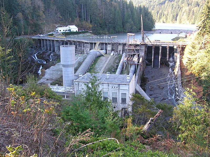
File:Elwha Dam.jpg
The dam before the opening of the spillways

Well, now the time is finally upon us, after numerous delays. The contracts have been written, the plans finalized, and the beginning of the end of these old and dangerous dams is here. Last week, they shut down the hydroelectric generators. Then, they opened the flood gates and spillways to full capacity to lower the level of the lakes in preparation for the actual removal later this summer. It is an amazing site to see so much water tumbling out of Lake Aldwell and the lake already down by around 15 feet.

Normally only a trickle came out from cracks in the old river channel

The old river channel was a 100 foot deep canyon that was blocked by the concrete wall. Today, water flows through at full force from the flood gates. Soon the river will flow in its original channel at the bottom of the cliffs.

The primary spillway is quite the cascade now!

They will close public access to Elwha Dam on July 1st and access to Glines Canyon Dam on August 1st. So, if you want to see these structures before their removal, you gotta go now. Then they will begin the preparatory process for removal, with actual demolition to begin around September 15th. It will take about 2.5 years to fully remove the dams and restore the river bed to its original state.

You can see the mud and old stumps that were under the lake


You can see the old concrete coffer dam here that redirected the river during original construction in 1912

When the original Elwha Dam blew out in 1910, they had to plug the holes with tons of gravel and fill. So, today there is a large hill of rock that will need to be removed. With the lake level down, you can now see the water flowing over the top of this fill almost like a river.

It almost looks like a river again already

It is going to be fascinating to watch the removal process via the webcams that will be set up by the National Park Service and then to visit the old lakebed in 2014 to see the river flowing free once again. It will take a long time for the vegetation to reestablish itself in the muddy lakebed. But, the salmon should start up the river almost immediately after removal. Hopefully, I'll get a chance to see salmon running up the river for the first time in 100 years!

Monday, May 30, 2011

Spruce Railroad Trail, Olympic National Park, Washington


Distance: 7.0 miles (11.3 km)
Elevation: 580 - 620 feet (177 - 190 m)
Difficulty: Easy
Time of Year: Anytime


Lake Crescent is one of the jewels of the Olympic Peninsula. Over 600 feet deep and with crystal clear cold waters, the lake shimers blue with cliffs that drop right from the lakeshore in the depths below. The lake is 12 miles long and about 2 miles wide. It was formed about 8,000 years ago, when a massive landslide blocked off Indian Creek and the valley filled with meltwater until it found an alternate drainage via the Lyre River. While most people experience Lake Crescent by driving on Highway 101 west of Port Angeles, the Spruce Railroad Trail offers people the chance to explore its beautiful shoreline in a more leisurely pace on the otherside and see some of the interesting features that makes this area so unique.

The bridge over Devil's Punchbowl

The Spruce Railroad Trail follows the old railroad bed that once followed the northern shore of this lake. The railroad was built to send spruce logs to the mills for World War I. However, the railroad was not completed until 1919, at which point the war was already over. The rails have been removed, but the grades make the trail wide and easy to follow in most places and the old railroad tunnels make for some fun exploration.

The trail on the old railroad grade

To access the Spruce Railroad Trail, take East Beach Road to the right off of Highway 101 about 25 minutes west of Port Angeles. Follow East Beach Road for 3 miles until you see the sign for "Spruce Railroad Trail" to the left. You will follow this road over the Lyre River and to the parking lot at the end.

Stonecrops clinging to the rocks

The trail will first start out through a forest of second growth Douglas fir and big-leaf maples for about 1/2 mile until it arrives along the edge of the lake. The first significant thing you will see is the spectacular "Devil's Punchbowl". This little exclosed "bay" is crossed by an arch bridge and the water is dozens of feet deep as the cliffs drop all around, making for a clear blue hole. This is a great place if you wish to go swimming. But, be warned the water temperature hovers around 45 degrees even in summer. Typically there is a thermoclime of a few inches, where the top layer is near 70 degrees and its freezing underneath. So, you may jump in and feel warm and then you realize your feet are suddenly numb!

A canoe parked at Devil's Punchbowl

The trail will then follow the shoreline, alternating between right along the rocky edges and up the slope a bit in forested patches. Along the rocky cliffs you will succulant stonecrops, indian paintbrush, and ferns clinging to the rocky crevasses. Another plant to watch out for in the exposed rocky talus is poison oak. Poison oak is pretty uncommon in Western Washington, but the south-facing slopes of Lake Crescent is one of the few places I have seen it. It is a reddish color in spring and fall, green in summer. Remember the old saying "If leaves of three - leave it be".

Poison oak

The trail will continue leisurely with views across to Barnes Point on the opposite side of the lake. Barnes Point contains Lake Crescent Lodge and is the primary spot for visitors to Lake Crescent on Highway 101 because the trail to Marymere Falls leaves from there. That peninsula sticking out into the lake formed when a massive landslide came down and piled debris into the lake. You can see the drainage where the landslide came down and formed Barnes Point clearly from this side of the lake.

Watch your step for banana slugs on the trail

The trail continues along steep rocky slopes, old landslide debris, in forested patches full of orchids, trillium, and ferns, and along the shores of the lake. Despite the highway across the lake, the trail is quiet with the only sounds being of towhee's singing in the trees, Douglas squirrels chirpping in disappoval of your arrival, and perhaps the sounds of oars of canoes on the lake.

The small hill in the middle is part of the the landslide that blocked Indian Creek and formed the dam that created Lake Crescent

The last 3/4 of a mile of the trail is completely in the woods until you arrive at the other trailhead at the end of the Camp David Jr. Road. This road leads to Fairholme Campground and Highway 101 on the western edge of the lake. If you wish to access the trail from the west (i.e. if you were camping at Fairholme), then you simply do the trail in reverse.

The azure waters of the lake from the trail

From here, you simply turn around and return the way you came. Going the otherway allows you a chance to look carefully for the little plants and animals you may have missed on the way out. While this trail can be busy on weekends, due to its low elevation it is available year round and if you go on a weekday in winter, you will have it all to yourself. The nice thing about its southerly exposure is that it gets a lot of sun, which is especially nice in those dark winter days.

The Douglas squirrels are never afraid to let you know what they think of your presence

Just Giving Back For All To Enjoy

Why pay money to buy hiking books? Why pay fees to view trail websites? By searching my archives and checking back often to see new posts, we are sure you will be able to find the hike that is right for you ... and for free!

In addition, we provide fascinating ecological and geological information to make the hikes informative and fun. As former National Park Rangers, we know how to find the right hike for you. So, if you are on vacation, we will provide you with the hike you absolutely MUST do while in an area. Do not go on vacation without checking out this site!