Sunday, December 9, 2012

Sandy's Canyon - Walnut Canyon, Coconino NF, Arizona


Distance: 6 - 8+ miles 
Elevation: 6834 - 6590 feet
Difficulty: Easy
Time of Year: Anytime (watch for ice and snow in winter)


Located just a stone's throw from Flagstaff, Arizona is a hidden gem to explore. While many people who travel through the area may be aware of the amazing cliff dwellings within Walnut Canyon National Monument about 5 miles east of Flagstaff, most people probably do not realize that they can hike into the spectacular canyon just a few miles upstream.


The trail can be accessed by driving down Lake Mary Road abput 5 miles south of Downtown Flagstaff (near the intersection of I-40 and I-17) toward Mormon Lake. Before reaching Lake Mary, look for the Canyon View Campground on your left. Park just outside of the campground and a trail will leave toward the canyon rim. To the right, an access trail heads down to the cliffs where rock climbers hone their skill. Stay left and the trail will take you down into the upper reaches of Walnut Canyon in a side-canyon called "Sandy's Canyon"

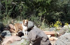
Hilina pounding out the resprouting grasses after a prescribed burn

Prior to the building of the dam on Lake Mary to contain the waters that make up 50% of Flagstaff's water supply, Walnut Canyon actually contained a free-flowing creek that sustained the ancient Sinagua people's of the area. As you hike into the canyon, you can see evidence of this once flowing creek in rounded river rocks that have mostly since overgrown with grasses and shrubs today.

Slash piles along the first 1.4 mile stretch of the trail

The first 1.4 miles takes you along a grassy meadow with encroaching pines. But, Coconino National Forest has been working vigorously in recent years to clear out the brush and do prescribed burns to reduce the risk of catastrophic wildfires from burning up this treasure. There will be large slash piles along the trail, as well as, freshly burned grasses in places.


The trail will merge with the Arizona Trail as it heads on its 800 mile trek from Utah to Mexico. Then it comes to an intersection. To the left, the Arizona Trail heads up slope toward Fisher Point Vista, which sits high above you. That trip is about 1.1 miles one-way. There is another route heading right that goes into the heart of Walnut Canyon. The layered rocks ahead of you are Coconino Sandstone, which represent the tilted layers of ancient sand dunes when the region was one of the world's largest deserts some 260 million years ago.

Fascinating cross-bedding of the Eolian strata of the Coconino Sandstone
A sign will warn you that you are entering a special vegetative area and that the trail ends in about 1 mile. It does contain a variety of riparian trees, small stands of aspen, and large Douglas firs. But, it probably had much larger and more diverse flora when water still ran in the canyon, such as the namesake Arizona walnut trees.


As for the trail, it doesn't really end. Instead, it becomes narrower, more brushy, and less maintained the further into the canyon you go.Eventually, the trail turns into nothing more than a game trail. But, the narrowing canyon walls, fascinating vegetation, and the spirits of the Sinagua people's draw you deeper down the canyon.


Theoretically, you could continue for another 4+ miles until reaching the boundary fence for Walnut Canyon National Monument. But, there is no further access beyond that. Even on warm fall and spring days, be prepared for very icy conditions in the narrower sections of the canyon. We went on a day when it was 60 degrees and had been for nearly 2 weeks. But, because the canyon floor never sees sunlight in fall and winter, ice continued to cover the trail, making it difficult to walk on in places.


Eventually, you just decide the point where you want to turn back and retrace your steps back to the car. But, if you wish to also see what the canyon looks like from above, you can head up on a side trip to Fisher Point to see up and down the canyon.

Looking down Walnut Canyon from above


Friday, December 7, 2012

Square Tower Loop, Hovenweep National Monument, UT


Distance: 2.0 miles
Elevation: 5220 - 5120
Difficulty: Easy
Time of Year: Anytime (avoid mid-day heat in summer)

Sleeping Ute Mountain rises above the "Twin Towers"

Hovenweep National Monument is located in a remote corner of southeastern Utah, just a couple of miles from the Colorado border. It is so remote, that you have to drive 28 miles off of the main highway (US-191) between Blanding and Mexican Hat, UT on rough county roads to reach it. But, even the main highway is in pretty remote territory. But, if you are on your way to Moab from Arizona or on your way south, it is well worth the detour, as it protects the some of the greatest examples of free-standing stone masonry of the Anasazi/Puebloan cultures in the entire Desert Southwest.


From US-191, there is a sign indicating the turn onto UT-262. Then, there are a series of turns onto various county roads to reach Hovenweep. But, there are always signs to let you know where to turn. But, just in case, it might be a good idea to have your GPS ready. Hovenweep is actually a conglomeration of six individual sites along the desolate Cajon Mesa that at one time supported a population approaching 2,500 people. The largest site is the Square Tower Group. That is where the main visitor center is, as well as, this particular loop trail. One additionally nice thing about this hike is that it is dog friendly, which is rare for a national park.


The trail starts out from the visitor center as paved until it reaches the ledge of Little Ruin Canyon and the first of many masonry structures called Stronghold House. From here, the trail makes a loop around the canyon edge to see many structures. You can choose to go either direction, but we went counterclockwise (right) to see most of the structures straight away.

Many of the structures are visible on both sides of the canyon in the distance

The trail passes a number of structures and others are clearly visible on the otherside of the canyon. What is amazing about this site is that it supported a population estimated to be almost 1,000 people. Yet, the canyon bottom is dry and there are almost no trees on the landscape. It was inhabited between 500 and 1200 AD. But, that was a time when the region was cooler and wetter and there is a vast forest of pinyon pines and a riparian forest in the canyon floor. As the climate dried and the trees had been cleared for building materials and firewood, springs became more inconsistent and times more desperate. 


The villagers build retention walls along ditches draining into the canyon to back water up and allow it to soak into the soil and rock to replenish the springs. But, the mega-droughts of the 1200-1300's that did in so many other Puebloan cultures in the region also caused the citizens of Hovenweep to abandon the area.


There are a couple of cottonwoods and some willows in the canyon bottom today. But, for the most part, the trees are gone and the climate is very different. The trail passes some really unusual structures that are hard to determine their uses. Some sit isolated on large boulders, one sits within an eroded boulder itself, and others seem to neither fit the bill as religious structures, defensive towers, homes based on the location of their entrances or window. But, one theory is that several of them were store houses for corn and other crops.


Eventually the trail descends into the canyon bottom itself, allowing you to look up at the structures from below. The trail then climbs up the steep south face of the cliff approximately 100 feet on a trail carved directly into the rock and then shortly thereafter you return to the Stronghold House. Be aware of temperatures approaching 100 degrees in mid-summer and possible icy conditions in winter. But, most of the time the sun should be out and temperatures tolerable.


Just Giving Back For All To Enjoy

Why pay money to buy hiking books? Why pay fees to view trail websites? By searching my archives and checking back often to see new posts, we are sure you will be able to find the hike that is right for you ... and for free!

In addition, we provide fascinating ecological and geological information to make the hikes informative and fun. As former National Park Rangers, we know how to find the right hike for you. So, if you are on vacation, we will provide you with the hike you absolutely MUST do while in an area. Do not go on vacation without checking out this site!