Distance: 5.4 miles
Elevation: 4750 - 6650 feet
Difficulty: Strenuous
Time of Year: October - May
 |
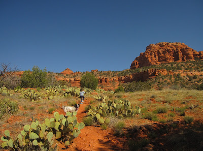
| The start of the trail with the first "step" ahead |
Bear Mountain may be the most spectacular day hike in the Sedona Red Rocks region, and that is saying a lot! It is very steep, quite rugged, but the views are absolutely incredible. The mountain is sort of like a large staircase, consisting of several more level areas punctuated by steep rocky inclines. However, as much as my knees ached following the hike, my little 5-year old daughter made it to the top, so it isn't too bad.
 |
| Approaching the amphitheater and the edge of the cliff to the 2nd "step" |
To access the trailhead, take Dry Creek road north from Hwy 89A in West Sedona to the junction with Boynton Canyon Road. Turn left and follow the road past the Boynton Canyon Resort and off toward Palatki Ruins. After passing the parking area for Fay Canyon, look for a large parking area on the left. From here, there are two trailheads. The easier and shorter Doe Mountain leaves from the lot, while Bear Mountain trail leaves from across the road.
 |
| The view from the top of the 2nd step with the Verde Rim visible |
The trail starts out crossing a couple of washes along the sediments at the base of the mountain. But, once you hit the red rocks, it climbs pretty steeply up the slope. Keep your eyes out for the rock cairns showing the safest route. The trail makes it to the top of the first "step" in under half a mile. But, then the trail heads up into an amphitheater and looking at the steep cliffs in the back you figure there is no way up on top of the plateau. Soon however, you head up a steep notch in deeply indented switchbacks and before you know it, you have a spectacular view looking down upon the flats and trailhead a few hundred feet down.
 |
| Hiking across the plateau of the 2nd step with Bear Mountain summit visible beyond |
The view from here would be impressive enough, but there is much more to do. Looking north, you can see the summit of Bear Mountain rising as just a smooth ridge a little above the plateau you are on. Looks can be deceiving. After a stretch of relatively flat hiking with an gradual incline, the trail comes up to the edge of two canyons dropping steeply down below. You have to descend down to the isthmus between the canyons and then the trail starts up again very steeply.
 |
| A view down onto the 2nd step (flat area) from the 3rd step |
Along this ascent, the rocks change over from the red Supai Group formation that is distinctive of Sedona to the wavey layers of Coconino Sandstone that preserve the ancient sand dunes of a once vast desert. The trail climbs up higher and higher, allowing views over the Verde Rim off to Granite Mountain and the Mazatzal Mountains far off to the southwest and southeast respectively. As the trail reaches the first ponderosa pines clinging to the precarious cliffs, a view into spectacular Fay Canyon opens up.
 |
| A view down into Fay Canyon from the Coconino sandstone |
The trail all-but-disappears on this sandstone, so it is very important to continue to watch for the rock cairns. Suddenly you feel like you are in a different world. This area has some real similarities to hiking at Zion National Park, as the cross-beaded sandstone has oaks and pines clinging to cracks above deep red canyons below. However, this is Coconino Sandstone, not the Navajo Sandstone found further north that would sit several layers higher if it had still remained in this area.
 |
| Pines clinging to Coconino sandstone beds near the top of Bear Mountain |
At the edge of the where the Coconino Sandstone transitions into Kaibab Limestone is one of the most spectacular places to rest and soak in the views. There are nice shade trees, flat rocks to lay or sit on, and a great place for a snack and drink before the final ascent to the summit. Truth be told, this is actually where the best views are. But, one must reach the summit I suppose, so after a long rest, it was time to conquer the final couple hundred feet.
 |
| San Francisco Peaks visible from the summit of Bear Mountain |
The climb on the Kaibab Limestone is slippery, dusty, and much more difficult footing than on the sandstone. You lose your views into the canyon as well. But, upon reaching the summit of Bear Mountain, you can get your first and only glimpse out across the Mogollon Rim and Coconino Plateau. The snow-capped San Francisco Peaks are visible to the north, while Bill Williams Mountain can be seen to the northwest. Since that is where most of the hikers will congregate, I didn't long and headed back down to my more shaded and lovely spot one level below.
 |
| Heading down across the Coconino Sandstone |
As hikers often say, it is much easier going up than going down. Not only is the traction easier, but your knees do not take the pounding. Thus, it often takes more time going down than it did to go up, despite taking more energy to go up. Now that you have to descend some 2,000 feet, take your time, soak in the views, and watch your footing.
 |
| Looking down into Fay Canyon |
In many ways, with the "goal" of reaching the top out of the way, it is easier to really just absorb the magnificent beauty of the region on your way down. But, do be warned if you have bad knees, take it easy and you probably should use hiking sticks to absorb the blows.
 |
| A view down one of the side canyons near "The Isthmus" |
Bear Mountain is a true masterpiece of Central Arizona. Be aware of extreme heat in summer. Rattlesnakes can be found on the trail in the heat of the summer as well. This hike should only be done in the spring or fall and be aware of possible ice in winter. But, if the weather is right and you are up to it, I am not sure any place in the region can be beaten for just pure scenic views and variety.


